Datoteca:Mt Vesuvius 79 AD eruption-la.svg

Datoteca originala (datoteca da SVG, grondezza da basa 800 × 480 pixels, grondezza da datoteca: 86 KB)
| Questa datoteca e las suandantas infurmaziuns provegnan dal deposit multimedia liber Wikimedia Commons. |
Resumaziun
| Descripziun |
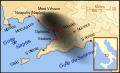
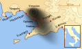
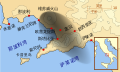
English: A map showing the cities and towns (with their Latin names which were affected by the eruption of Mount Vesuvius in 79 AD ; the general shape of the ash and cinder fall —see w:en:pyroclast— is shown by the dark area to the southeast of Mt Vesuvius.
This map shows modern day coast lines and uses the Mercator projection (although that is not important on a map of this scale). North is, as usual, at the top of the map. Español: El mapa muestra las ciudades y los poblados (con sus nombres en latín) que fueron afectados por la erupción del Vesubio del año 79 d.C. ; las cenizas y los residuos de la erupción volcánica —consultar Piroclasto (tefra)— cayeron al sureste del Monte Vesubio, donde está indicado por la zona oscurecida. |
| Data | |
| Funtauna | Eigenes Werk |
| Autur | MapMaster |
References
This map is intended to show the general distribution of (airborne) ash punice, and other particles. I built the map from descriptions of the event as well as these maps:
- Luongo, Giuseppe; Perrotta, Annamaria; Scarpati, Claudio;De Carolis, Ernesto;Patricelli, Giovanni;Ciarallo, Annamaria (2003) "Impact of the AD 79 explosive eruption on Pompeii" in Journal of Volcanology and Geothermal Research v126 pp. 169-200.
- This map.
- Image:Pompeya, el Vesuvio y su alcance.jpg
Other versions
[]
-
 English
 -
 français
 -
 Latina
 -
 Nederlands
 -
 português
 -
 македонски
 -
 русский
 -
 中文
中文 -
 עברית
עברית


|
Diese SVG-Datei enthält eingebetteten Text, der mit jedem geeigneten SVG-Editor, Texteditor oder dem SVG-Übersetzungs-Werkzeug in deine Sprache übersetzt werden kann. Für mehr Informationen siehe Über das Übersetzen von SVG-Dateien. |
Licenza

|
Es ist erlaubt, die Datei unter den Bedingungen der GNU-Lizenz für freie Dokumentation, Version 1.2 oder einer späteren Version, veröffentlicht von der Free Software Foundation, zu kopieren, zu verbreiten und/oder zu modifizieren; es gibt keine unveränderlichen Abschnitte, keinen vorderen und keinen hinteren Umschlagtext.
Der vollständige Text der Lizenz ist im Kapitel GNU-Lizenz für freie Dokumentation verfügbar. |
- Dieses Werk darf von dir
- verbreitet werden – vervielfältigt, verbreitet und öffentlich zugänglich gemacht werden
- neu zusammengestellt werden – abgewandelt und bearbeitet werden
- Zu den folgenden Bedingungen:
- attribuziun – Du musst angemessene Urheber- und Rechteangaben machen, einen Link zur Lizenz beifügen und angeben, ob Änderungen vorgenommen wurden. Diese Angaben dürfen in jeder angemessenen Art und Weise gemacht werden, allerdings nicht so, dass der Eindruck entsteht, der Lizenzgeber unterstütze gerade dich oder deine Nutzung besonders.
- Weitergabe unter gleichen Bedingungen – Wenn du das Material wiedermischst, transformierst oder darauf aufbaust, musst du deine Beiträge unter der gleichen oder einer kompatiblen Lizenz wie das Original verbreiten.
Istorgia da las versiuns
Clicca sin ina data/temps per vesair la versiun da lura.
| data/temp | Maletg da prevista | dimensiuns | Utilisader | commentari | |
|---|---|---|---|---|---|
| actual | 10:00, 6. avr 2018 | | 800 × 480 (86 KB) | -donald- | K changed to km |
| 00:04, 29. nov 2014 |  | 800 × 480 (88 KB) | Ras67 | frame removed | |
| 02:17, 19. oct 2007 |  | 659 × 396 (113 KB) | MapMaster | slight modification | |
| 00:35, 16. oct 2007 |  | 659 × 396 (113 KB) | MapMaster | slight image fix-up | |
| 19:52, 15. oct 2007 |  | 652 × 396 (113 KB) | MapMaster | == Summary == {{Information |Description=A map showing the cities and towns affected by the eruption of Mount Vesuvius in 79 AD. The general shape of the ash and cinder fall (see w:en:pyroclast) is shown by the dark area to the southeast of Mt Vesuvi |
Utilisaziun da la datoteca
La suandanta pagina è colliada cun questa datoteca:
Diever da datoteca global
Die nachfolgenden anderen Wikis verwenden diese Datei:
- Utilisaziun sin af.wikipedia.org
- Utilisaziun sin bg.wikipedia.org
- Utilisaziun sin br.wikipedia.org
- Utilisaziun sin ca.wikipedia.org
- Utilisaziun sin cs.wikipedia.org
- Utilisaziun sin da.wikipedia.org
- Utilisaziun sin de.wikipedia.org
- Utilisaziun sin de.wikivoyage.org
- Utilisaziun sin en.wikipedia.org
- Utilisaziun sin es.wikipedia.org
- Utilisaziun sin et.wikipedia.org
- Utilisaziun sin fi.wikipedia.org
- Utilisaziun sin fr.wikipedia.org
- Utilisaziun sin fur.wikipedia.org
Weitere globale Verwendungen dieser Datei anschauen.