Datoteca:Map German SpeakingWorld.png

Grondezza da questa prevista: 800 × 370 pixels. Other resoluziuns: 320 × 148 pixels | 640 × 296 pixels | 1.357 × 628 pixels.
Datoteca originala (1.357 × 628 pixels, grondezza da datoteca: 36 KB, tip da MIME: image/png)
| Questa datoteca e las suandantas infurmaziuns provegnan dal deposit multimedia liber Wikimedia Commons. |

|
File:Legal statuses of German in the world.svg ist eine vektorisierte Version dieses Bildes. Diese sollte an Stelle des Rasterbildes verwendet werden, sofern sie nicht schlechter ist.
File:Map German SpeakingWorld.png → File:Legal statuses of German in the world.svg
Für weitere Informationen siehe Help:SVG. |
 |
| Descripziun |
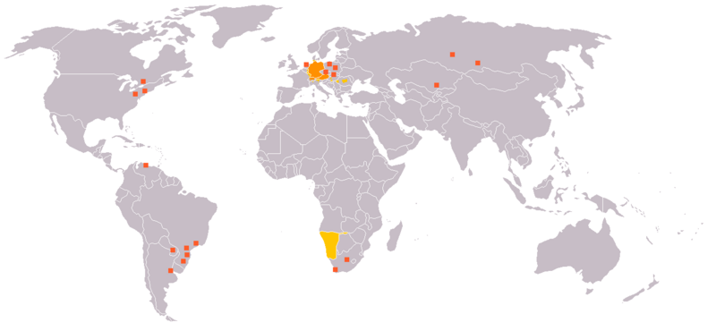
English: Legend:
Deutsch: Legende:
Français : Carte du monde où on parle l'allemand.
עברית:
Italiano: Legenda:
Nederlands: Beschrijving:
Svenska: Beskrivning:
|
||||||||
| Funtauna | en:Image:Map_German_World.png | ||||||||
| Autur | en:User:Ilario. | ||||||||
| permissiun (Weiternutzung dieser Datei) |
Ich, der Urheberrechtsinhaber dieses Werkes, veröffentliche es hiermit unter der folgenden Lizenz:
Du darfst es unter einer der obigen Lizenzen deiner Wahl verwenden. |
||||||||
| Andere Versionen | File is obsolete! Use File:Legal statuses of German in the world.svg instead. |

Istorgia da las versiuns
Clicca sin ina data/temps per vesair la versiun da lura.
| data/temp | Maletg da prevista | dimensiuns | Utilisader | commentari | |
|---|---|---|---|---|---|
| actual | 22:35, 18. fan 2020 | | 1.357 × 628 (36 KB) | Maphobbyist | South Sudan and Montenegro borders |
| 11:14, 11. nov 2007 |  | 1.357 × 628 (46 KB) | Domaleixo | ||
| 20:28, 27. fan 2006 |  | 1.357 × 628 (25 KB) | Cwlq~commonswiki | ||
| 08:18, 28. zercl 2006 |  | 1.357 × 628 (37 KB) | Highpriority | {{Information |Description=en: Legend: *Orange: native language *Gold: Secondary language or non-official. *Red-orange square: German minorities de: Legende: *dunkles Orange: Amtssprache/Muttersprache *helles Orange: Zweitsprache oder nicht offiziel |
Utilisaziun da la datoteca
Naginas paginas mussan sin questa datoteca.
Diever da datoteca global
Die nachfolgenden anderen Wikis verwenden diese Datei:
- Utilisaziun sin de.wikipedia.org
- Utilisaziun sin fr.wikipedia.org
- Utilisaziun sin incubator.wikimedia.org