Datoteca:The Danube Spills into the Black Sea.jpg

Grondezza da questa prevista: 669 × 600 pixels. Other resoluziuns: 268 × 240 pixels | 535 × 480 pixels | 857 × 768 pixels | 1.142 × 1.024 pixels | 2.080 × 1.865 pixels.
Datoteca originala (2.080 × 1.865 pixels, grondezza da datoteca: 1,07 MB, tip da MIME: image/jpeg)
| Questa datoteca e las suandantas infurmaziuns provegnan dal deposit multimedia liber Wikimedia Commons. |
Resumaziun
| Descripziun |
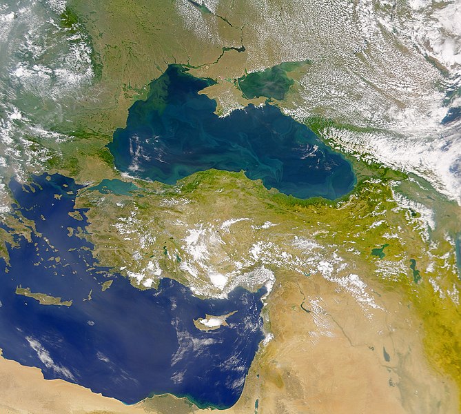
English: This cloud-free Sea-viewing Wide Field-of-view Sensor (SeaWiFS) view of the Black Sea reveals the colourful interplay of currents on the lake’s surface. The green crescent shaped pattern in the north-western corner of the Black Sea is due to the nutrient-rich, sediment-laden discharge of the Danube River stimulating biological activity. The brighter, more turquoise patterns on the lake to the south and east are probably blooms of another type of phytoplankton. |
| Data | |
| Funtauna | NASA Earth Observatory |
| Autur | The SeaWiFS Project |
Image courtesy of the NASA/Goddard Space Flight Center, and ORBIMAGE.
Licenza
| Diese Datei ist gemeinfrei (public domain), da sie von der NASA erstellt worden ist. Die NASA-Urheberrechtsrichtlinie besagt, dass „NASA-Material nicht durch Urheberrecht geschützt ist, wenn es nicht anders angegeben ist“. (NASA-Urheberrechtsrichtlinie-Seite oder JPL Image Use Policy). | ||
 |
Warnung:
|
Istorgia da las versiuns
Clicca sin ina data/temps per vesair la versiun da lura.
| data/temp | Maletg da prevista | dimensiuns | Utilisader | commentari | |
|---|---|---|---|---|---|
| actual | 13:20, 20. avr 2010 | | 2.080 × 1.865 (1,07 MB) | Originalwana | {{Information |Description={{en|1=This cloud-free Sea-viewing Wide Field-of-view Sensor (SeaWiFS) view of the Black Sea reveals the colourful interplay of currents on the lake’s surface. The green crescent shaped pattern in the north-western cor |
Utilisaziun da la datoteca
La suandanta pagina è colliada cun questa datoteca:
Diever da datoteca global
Die nachfolgenden anderen Wikis verwenden diese Datei:
- Utilisaziun sin ady.wikipedia.org
- Utilisaziun sin crh.wikipedia.org
- Utilisaziun sin en.wikipedia.org
- Utilisaziun sin eo.wikipedia.org
- Utilisaziun sin fr.wikipedia.org
- Utilisaziun sin gu.wikipedia.org
- Utilisaziun sin hak.wikipedia.org
- Utilisaziun sin hr.wikipedia.org
- Utilisaziun sin hu.wikipedia.org
- Utilisaziun sin ilo.wikipedia.org
- Utilisaziun sin ja.wikipedia.org
- Utilisaziun sin kn.wikipedia.org
- Utilisaziun sin lg.wikipedia.org
- Utilisaziun sin pl.wikipedia.org
- Utilisaziun sin sr.wikipedia.org
- Utilisaziun sin ta.wikipedia.org
- Utilisaziun sin uk.wikipedia.org
- Utilisaziun sin vi.wikipedia.org
- Utilisaziun sin wuu.wikipedia.org
- Utilisaziun sin zh.wikipedia.org